by: Hartatik
Semarang – Thousands of factory workers in the Tanjung Mas Port industrial area, Semarang, Central Java, panicked following the collapse of the sea water barrier on Monday (23/5) evening. In a matter of minutes, high tide at the time with a height of 1.5 to 2.5 metres, immediately turned the harbour area into the ocean.
Video of the moment the embankment broke has gone viral on social media. Konah (40), a garment factory worker, admitted that she was desperate to evacuate her motorcycle, worrying that it would get damaged if it was submerged in the tidal flood for too long. The flood, known locally as ‘rob’, has reached the seat of the motorcycle.
“Initially, my friends and I ran without bringing our motorcycles when I found out that the tidal flood had started to enter the factory area,” Konah said. After knowing that the tidal flood was getting higher, she decided to return to the factory to pick up her motorcycle.
Similarly, Nela Aji (35), a worker at a different garment factory, PT Korina in the port area of Semarang said that she ran for safety after hearing the factory siren blared at around 13:45.
“I saw people running and screaming, ‘rob’, ‘rob’. Without thinking, I immediately turned off the engine and saved myself,” she said, recalling the incident.
She said many of her co-worker’s motorcycles had to be left in the factory parking area, because the owners had saved themselves. Meanwhile, Nela’s friend, Diah, said that this was the first time she had experienced tidal flooding of around 120 centimetres or as high as an adult’s chest.
Apart from motorcycles and cars, thousands of sewing machines and production machines at a number of factories were also submerged by the tidal flood. Dozens of containers at the Tanjung Emas Port were also submerged by the tidal flood.
The Regional Disaster Management Agency (BPBD) of Central Java Province said that tidal flooding in the Tanjung Mas Port area was exacerbated by the bursting of seawater retaining levees at two points around 2.5 kilometres apart, the area around PT Lamicitra Nusantara and Kampung Ujung Seng. Depth of the tidal flood in this area varied between 40 cm up to 1.5 metres.
Perigee phenomenon
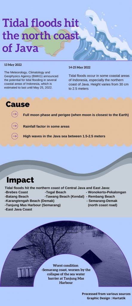
Direct observation showed that the tidal flood occurred widely on the northern coast of Java, namely the coast of Tegal Beach, Wonokerto-Pekalongan, Sari-Pekalongan Beach, Batang Beach, Tawang Kendal Beach, Tanjung Emas Harbour in Semarang. As well as, Jalan Raya Genuk Semarang-Demak, Karang Tengah Beach in Demak, Rembang Beach, and the coast of East Java.
Central Java Meteorology, Climatology and Geophysics Agency (BMKG) estimates that the potential for increasing sea level heights in the northern coast of Central Java will still occur until the last week of May.
Head of the Semarang Tanjung Emas Maritime Meteorology Station, Retno Widyaningsih, stated that the peak of the sea tide had occurred on Monday (23/5), with a high tide of 210 centimetres. The meteorology office had issued an early warning regarding the potential for tidal flooding and high waves in a number of coastal areas, including Semarang, on Monday and Tuesday (23/5-24/5).
Demak, Pati, Pekalongan and Rembang.
“The wave height in the northern waters of Central Java reaches 1.25 metres to 2.5 metres or is in the medium category. We have appealed to the public, especially those living in coastal areas, to always be vigilant in their activities around the coast,” said Widyaningsih.
BMKG also informed that the tidal flood coincided with the full moon phase and perigee position of the moon. The perigee phenomenon occurs when the moon is at its closest position to the earth. In addition, according to BMKG, tidal flooding was also exacerbated by rainfall in several areas. All of this has an impact on increasing tidal flooding on the north coast of Java Island.
The Mayor of Semarang Hendrar Prihadi, said that high tides do not only occur in the city of Semarang, but also in several regions on the north coast.
“Several areas on the north coast have also reported the same condition. Only (the occurrence) in the city of Semarang is unexpected, because there is one point that has been safe so far, but Monday (23/5) yesterday it was submerged in water to a height of 1-1.5 metres,” said Prihadi.
According to him, the high tide this time was the highest in the last decade. The previous highest high tide occurred in June 2020, which was 1.8 metres high. On May 23, the high tide reached 2.1 metres. “So some (of the water) ran off, some caused the embankment to burst.”
Sea Toll
Meanwhile, Governor Ganjar Pranowo said this tidal flood occurred due to weather anomalies. BMKG, he said, continued to update the information and informed that the rise in sea level will be high in the near future. Furthermore, Pranowo said the sea wall was a long-term solution for handling tidal flooding in the northern region of Central Java.
He said at the same time, groundwater extraction in coastal areas must be controlled. In the Pekalongan area, for example, currently there is a sea wall being built, and in the vicinity of Semarang-Demak there is a toll road construction which will also function as a tidal barrier.
“Indeed there must be quite strict regulations in this coastal area. If buildings still draw a lot of ground water, we will continue to experience this,” explained Pranowo.
Based on temporary data from the River Basin Center (BBWS), Directorate General of Water Resources, Ministry of Public Works and Community Housing (PUPR) Pemali Juana, said the impact of the tidal flood resulted in the inundation of Tanjung Emas Port, Semarang by about 30-150 centimetres and the Meduri River which passed through Pekalongan Regency and City overflowed to inundate several settlements, residents and roads in the villages of Tegal Dowo, Pasir Sari, Karang Jompo, girlfriend, Samborejo, Meduri, Pulosari, and Mulyorejo.
The tidal flood on the North Coast of Java also affected parts of Demak Regency up to a height of 30-100 centimetres, such as the Pantura Demak Highway and residential areas in Pondok Raden Patah. Expert Staff of PUPR for Technology, Industry and Environment and spokesman for the Ministry of PUPR Endra S Atmawidjaja said sea tides reaching around 210 cm can be called extreme when compared to the tidal record of the last five years (2017-2021), with the highest tide level in range of 180 cm above sea level.
Regarding efforts to handle tidal flooding on the Java north coast in the long term, Atmawidjaja said PUPR continued to build flood control infrastructure in stages. For the Semarang City area, among others, the construction of the Jatibarang Dam for upstream handling and construction of flood canals, river normalisation, tidal levees, pumping stations, retention ponds, including the Gerak Weir in the West Flood Canal for downstream handling.
To prevent tidal runoff, the PUPR has also built a tidal embankment that stretches for 2.17 km from the Sultan Agung Islamic University (Unissula) campus, encircling the Terboyo industrial area to the Sringin River. In addition, there is also the construction of the 27 km Semarang-Demak Toll Road which also functions as a sea wall.
Global Warming Impact
Meanwhile, an expert on coastal and marine geomorphology at Gadjah Mada University (UGM), Dr Bachtiar W Mutaqin SKel MSc, assessed that the Banten to Banyuwangi area had long been known as an area prone to tidal flooding. This is due to global warming in the form of rising sea levels, and soil material in northern Java that is not yet stable.
He said there are a number of settlements built on the unstable ground. “Not only private or individual settlements but also on an industrial scale (constructions), so they may use groundwater. As a result, there are many problems, quite complex, starting from sea level rise, then the alluvial soil material is still young, and it is also related to land use,” he said quoted from the UGM website, Thursday (26/5).
Mutaqin, who also lectures at the UGM Faculty of Geography, said that there is a long history of tidal flood events in Semarang. The history of tidal waves is very frequent and the current event coincides with the high tides. Tidal floods in Semarang averaged 40-60 cm and had reached one metre in 2013.
“The tide is quite high, the embankment is broken, so finally the area on the coast of Semarang is submerged,” he said, adding that although the government had mitigated the situation, the sea level is quite high. The phenomenon caused a number of buildings to collapse and many submerged.
Mutaqin explained that the soil material in northern Java actually comes from sediment or sedimentation processes from rivers. The sedimentary material when measured from a geological scale is still young and unstable, not solidified or not compacted yet. The fact that on it stood many buildings, made the situation even more difficult. The situation was also exacerbated by the use of ground water which resulted in land subsidence, which in Semarang has reached around 19 cm per year.
“Even though tide stations already exist, there is a sea wall, but during the last incident, the tide phenomenon was quite high compared to usual. Maybe because it is still in extreme conditions for the weather, it is even estimated that it will last until June for the peak tide,” he explained.
Mutaqin emphasised that in general the government already understands what is happening in Semarang and other areas on the north coast of Java, which have long been known as tidal-prone areas. In the future, he said that in relation to spatial planning, land subsidence needs attention. He said, it is necessary to regulate the use of land, especially in coastal areas, so that it is not too massive.
The same applies to large-scale industries and the use of groundwater, which usually has a much larger capacity than ordinary households, thus needs to be regulated. He said that in Demak, one village was lost due to tidal flooding and land subsidence.
“We hope that there is some kind of moratorium or regulation that prohibits the use of ground water on an industrial scale or something like that needs to be done as well,” said Mutaqin.
He explained that the people who live on the coast actually understand the risks they face, but due to economic limitations, they have no other option or choice. These conditions make them inevitably have to adapt.
This is in accordance with conditions in the Asia Pacific that are increasingly worrying following the decline in the disaster preparedness scores of countries in the region, including Indonesia. That means these countries are increasingly vulnerable to potential natural disasters. In this regard, the Indonesian government as the host encourages the recent Global Platform for Disaster Risk Reduction (GPDRR) to formulate real solutions in dealing with the threat of disasters caused by climate change. (Hartatik)
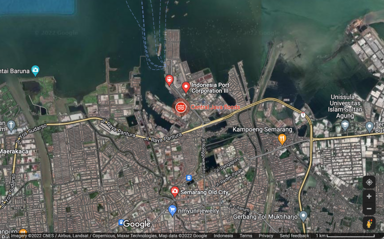
Banner photo: Google Map screen shot, showing flood alert in Semarang